


mont Foirmont et Châtelaine.

dcharbonnier
User
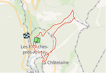

Length
8.5 km

Max alt
579 m

Uphill gradient
284 m
Km-Effort
12.2 km

Min alt
321 m

Downhill gradient
282 m
Boucle
No
Creation date :
2020-10-25 12:18:06.549
Updated on :
2020-10-26 07:30:11.415
2h22
Difficulty : Easy

FREE GPS app for hiking
 SityTrail
IGN / Geographical institutes
SityTrail Plus
The world is yours!
About
Trail Walking of 8.5 km to be discovered at Bourgogne-Franche-Comté, Jura, Les Planches-près-Arbois. This trail is proposed by dcharbonnier.
Description
Arbois les Planches variantes.
Positioning
Country:
France
Region :
Bourgogne-Franche-Comté
Department/Province :
Jura
Municipality :
Les Planches-près-Arbois
Location:
Unknown
Start:(Dec)
Start:(UTM)
713739 ; 5195680 (31T) N.
Comments